Google Maps is the first tool most transportation coordinators think of when they need to map a bus route quickly. It's free, familiar, and available on every device. For a sub driver covering a single route tomorrow morning, that's often enough.
But school districts managing real school bus fleets face a harder reality. With approximately 25 million K-12 students transported daily on an estimated 480,000 yellow school buses, the operational complexity behind those routes goes well beyond what a consumer navigation app was built to handle.
This guide walks through exactly how to build and customize a school bus route in Google Maps, step by step. It also covers where the tool hits its limits for K-12 use cases — and what transportation teams typically do once those limits become a real problem.
Key Takeaways
- Google Maps supports up to 9 total waypoints per route, including origin and final destination
- Routes can be customized to avoid highways and tolls, and adjusted by dragging the route line
- Google Maps has no student assignment, SIS integration, fleet-wide view, or real-time tracking
- Route links shared with drivers are static — any stop change requires manually resending the link
- Districts managing multiple routes or mid-year enrollment changes need dedicated routing software with SIS sync, live tracking, and driver communication built in
How to Create and Customize School Bus Routes Using Google Maps
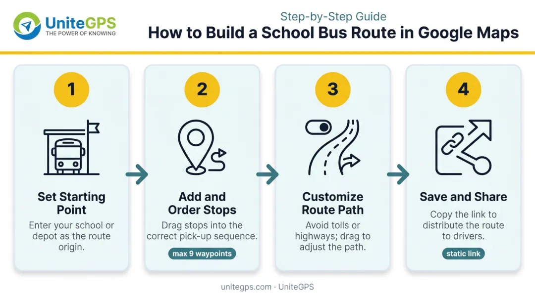
Step 1: Set Up Your Starting Point and Mode
Open Google Maps on desktop or mobile. Click the Directions button and select Driving mode. Enter the bus garage, depot, or school as your starting point — this establishes the origin for the route's first leg.
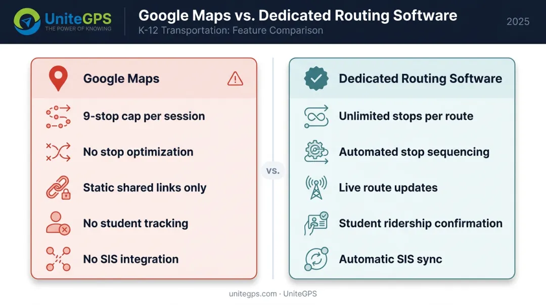
Before you add a single stop, understand the hard ceiling: Google Maps allows a maximum of 9 total waypoints per route, including the origin and final destination. Any bus route with more stops must be split across multiple separate map sessions and tracked externally.
For most real-world routes, that means managing several disconnected maps just to cover one bus.
Step 2: Add and Order Bus Stops
Click "Add destination" to enter each pick-up or drop-off address in the intended service sequence. Reorder stops by clicking and dragging them in the sidebar panel.
A few things Google Maps will not do here:
- Follows the sequence you enter — no optimization for geographic efficiency
- Ignores road-safe stopping zones and school driveway constraints
- Has no awareness of bell schedule windows or turnaround limitations
- Cannot flag hazardous crossings or low-clearance roads near stops
The stop sequence is entirely your responsibility to determine before entering addresses.
Step 3: Customize the Route Path
Open the Options menu from the route panel to enable:
- Avoid tolls — relevant for districts with policy or budget restrictions
- Avoid highways — required for school buses restricted from certain road types by district policy or state regulation
To force the bus onto a specific road segment, drag the blue route line directly on the map. This is the primary customization tool available. Use it to bypass roads with known hazards, low clearances, railroad crossings, or active construction zones.
Step 4: Save and Share the Route with Drivers
Save the route to a Google account for future reference, or use the "Share directions" feature to generate a shareable link for email or text delivery to a driver.
Shared links are static snapshots. If a stop changes mid-year, the driver receives no automatic update — there is no live route management or push-notification capability in Google Maps sharing.
A coordinator must manually send a new link every time anything changes, and hope the driver knows to use it.
When Google Maps for School Bus Routing Makes Sense
Google Maps is genuinely adequate for a narrow set of scenarios:
- A sub driver covering an unfamiliar route for a single day
- A transportation coordinator previewing a proposed new route before presenting it to administration
- Verifying road conditions around a new or relocated stop
Small charter schools or districts just launching transportation programs sometimes use Google Maps as a temporary stopgap. It provides a visual map reference at zero cost, which is a real advantage when budgets are tight and routes are few.
That advantage has limits. Once a district manages five or more active routes, handles mid-year address changes, or needs to track ridership, the manual effort compounds quickly. Most districts find themselves searching for dedicated routing software within a single school year.
What Google Maps Cannot Do for School Bus Routing
The 9-Stop Ceiling vs. Real Route Complexity
Most school bus routes involve far more than 9 stops — state transportation reporting systems like Florida's track stop counts at the district level precisely because routes are stop-intensive operations. Google Maps cannot handle a full route in a single session, forcing staff to manually split routes across multiple maps and maintain a separate system to track which stops belong to which session.
No Student Assignment or Ridership Tracking
Google Maps plots geography. It has no concept of which students board at which stop, whether a child was present, or whether a student was safely delivered. There is no mechanism to:
- Flag attendance anomalies
- Manage split-custody drop-off variations
- Confirm a student boarded or exited at the correct stop
- Document rides for IEP or Medicaid compliance
That gap in student-level data points to a broader problem: Google Maps has no connection to the systems that actually manage enrollment.
No SIS Integration, No Fleet-Wide View
Every student address must be entered manually in Google Maps. When enrollment changes — a student moves, transfers, or modifies their transportation arrangement — there is no automated update. Transportation staff must manually correct each affected map. This becomes an error-prone task fast.
Beyond individual route management, there is no unified dashboard to:
- View all active routes simultaneously
- Compare coverage zones
- Identify gaps or overlapping paths
- Make fleet-wide adjustments
No Real-Time GPS Tracking or Parent-Facing Visibility
Once the bus leaves the garage, Google Maps provides nothing. Transportation offices cannot monitor whether buses are on schedule, and parents have no way to check arrival times. A 2021 Zonar/Harris Poll survey found 75% of parents wanted a better way to track their child's journey to and from school, and 51% wanted real-time school bus information during emergencies. Google Maps addresses none of those needs.
Common Mistakes When Using Google Maps for School Bus Routing
These three mistakes show up repeatedly when coordinators first start using Google Maps for routing:
- The 9-stop limit catches people off guard. Coordinators often don't discover the waypoint cap until the "Add destination" button stops responding mid-build. Stops can be silently dropped, leaving a route that looks complete but is missing student pickups.
- Google Maps doesn't optimize stop order. It finds the fastest path between stops in the sequence you enter — nothing more. Enter stops in enrollment order instead of geographic order and you'll end up with a route that doubles back on itself, burning extra time and fuel.
- Shared links go stale. When a stop changes mid-year, the shared link doesn't update. The driver has no way of knowing the route is outdated — a genuine safety gap, not just an inconvenience.
A Better Alternative: Purpose-Built School Bus Routing Software
Districts managing more than a handful of routes encounter Google Maps limitations that purpose-built K-12 transportation software is specifically designed to solve.
What to look for in dedicated school bus routing software:
- Unlimited routes with automated stop sequencing and timing recalculation
- SIS data synchronization so address changes update routes automatically — not manually
- Real-time GPS tracking with a fleet-wide dashboard showing every bus simultaneously
- Student ridership confirmation — scan-verified boarding and alighting records
- Parent-facing apps with live bus location and push notifications
- Driver tablet navigation built for school bus road restrictions and weight limits
UniteGPS Crosswalk is built specifically for K-12 districts moving from spreadsheets, printed maps, or Google Maps to a dedicated system. The platform brings route planning, real-time GPS tracking, student ridership tablets, and SIS integration — compatible with PowerSchool, Infinite Campus, Skyward, and Harmony — into one place.
Tim Lyons, Director of Transportation at Benton Community School District, put it plainly: "If a parent calls saying the bus didn't stop, we can look and see that they were there. It has made a huge difference in our district."
That kind of accountability comes standard. Districts can start with core routing and layer in GPS tracking and ridership features as operational needs grow. UniteGPS offers a 90-day free trial with routes built at no cost and no credit card required — plus unlimited live support with no tickets, no queues, and no chatbots. The right tool is only half of it; the other half is a partner who doesn't sell you software and walk away — one who stays, shares what they know, and helps you build a transportation operation your district can be proud of. Great student transportation starts with great leaders — and we build both.
Frequently Asked Questions
Can you make a school bus route on Google Maps?
Yes, Google Maps can build a basic multi-stop driving route. However, it is capped at 9 total waypoints per session (including origin and final destination) and lacks any school-specific features such as student assignments, SIS integration, or real-time tracking.
How many stops can you add to a route in Google Maps?
Most real-world school bus routes exceed that 9-waypoint cap in a single run, forcing coordinators to split the route across multiple separate map sessions.
Does Google Maps have a school bus routing mode?
No. Google Maps offers driving, transit, walking, cycling, and ride-sharing options, but none are configured for K-12 student transportation. There is no school bus mode, no bell schedule awareness, and no safe stop placement guidance.
Can Google Maps track a school bus in real time?
No. Google Maps does not provide real-time GPS tracking for school buses. Once a route is shared with a driver, there is no live location feed available to transportation staff or parents.
How do I share a Google Maps route with a bus driver?
After building a route, click the share icon to generate a shareable link, which can be sent via text or email. Keep in mind the link is static: it will not reflect any future stop changes, and the driver receives no notification when the route is updated.
What is the best software for planning school bus routes?
Purpose-built K-12 transportation platforms that combine route planning, GPS tracking, student ridership, and SIS integration are the recommended solution for districts managing multiple routes. UniteGPS Crosswalk is one such platform built specifically for K-12 districts, offering integrated routing, live tracking, and student ridership tools in a single system.
How hard is it to move a stop or a student from one route to another?
In dedicated routing software, it takes a few clicks. You attach students to stops and zones once, and reassigning a stop — or moving a student to a different route — recalculates the affected stop times automatically. That's a sharp contrast with Google Maps, where every change means manually rebuilding and resharing a static link.
How do you handle a student who lives with one parent one week and the other the next?
Purpose-built platforms handle split-custody and dual-address situations directly — a student can ride Route 2 during week A and Route 3 during week B, or board different stops on different days. This is often called day-of-the-week routing, and it's exactly the kind of scenario a single Google Maps route can't represent.
How long does implementation take, and what does it require from us?
Far less effort than maintaining a patchwork of Google Maps links. A named implementation contact builds your initial routes with your team — and for districts with no existing documentation, routes can be reconstructed from GPS history. GPS devices ship pre-labeled and pre-assigned, so installation is plug and play. Core routing and GPS typically go live within weeks, and the 90-day free trial covers the whole setup, so you're never doing the heavy lifting alone.
Can we do year-to-year? Our board restricts long-term contracts.
Yes. UniteGPS contracts are year-to-year with annual invoicing — no multi-year commitment — and the terms go in writing on the quote. That matters for districts whose board or legal counsel limits agreements to a set term.